SPOTTED – Satellite Open Data for Smart City Services Development Supports Public Administrations in the field of green areas management.
Challenges & context
SPOTTED aims to provide an innovative solution based on the integration and personalised processing of huge collections of open data, including Earth Observation (EO) data, to monitor and support decision makers in the field of managing 3 different digital services. The ultimate goal is to show how this project will generate innovation and create great value through the implementation of three pilot services in Milan, Helsinki, and Naples, focused on monitoring and planning green areas in cities in relation to various factors (e.g. tourism impact, quality of life, economic growth, etc.).There is also the possibility to monitor and observe heat exposure and vulnerability to urban heat with specific detection tools.
Description of the solution
SPOTTED is an integrated environment based on mature existent dataset that will be able to collect information from heterogeneous open data sources, including satellite images combine them and provide data analytics through visual dashboard and maps.The SPOTTED project uses open data, focusing on categories such as geospatial and earth observation. Key tools include datasets based on DCAT-AP (Data Catalog Vocabulary for European Data Portals) and GeoDCAT-AP to ensure metadata standardization. The interoperability of open data is ensured through the use of APIs, facilitating access and sharing of datasets through the European Data Portal and national open data portals.
SPOTTED Impact
The impact of SPOTTED is to provide contributors with a direct interactive experience on the platform. Layer mapping allows you to visualize data on the map based on the digital services you select, allowing users to see meaningful information and make decisions based on how the datasets they upload to the portal behave and see the evolution and development which follows. In summary, SPOTTED revolutionizes the way in which datasets are processed and presented, offering a direct and personalized impact in the context of digital services, improving the usability of information and the relevance of the resulting decisions.
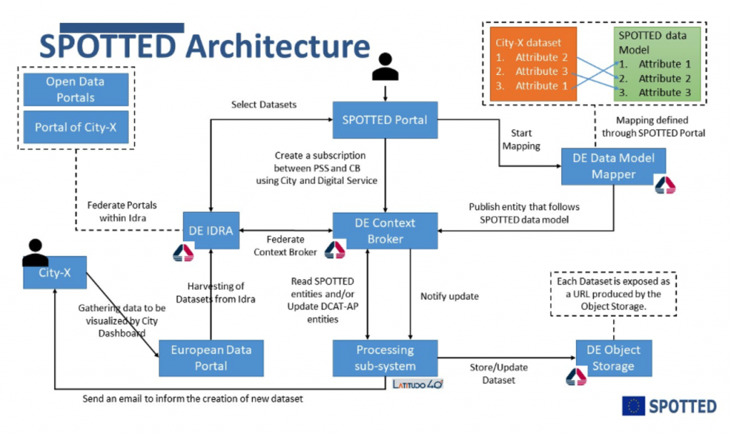
Technical Description
The SPOTTED platform works as an integrated environment based on displaying data on map layers. It collects information from various heterogeneous sources of open data that are provided by those who use them and then processes them in our application, including satellite images, and combines them providing data analysis through visual dashboards and interactive maps, showing different types of results based on the type of dataset that is served to him.
This is the technical architecture of the spotted infrastructure.
Recommandations
The integration of SPOTTED in the cities of Milan, Helsinki and Naples promises a significant impact in the management of green areas and in the evaluation of critical factors such as tourism impact and quality of life. The advanced solutions offered, such as visual dashboards and interactive maps, demonstrate how SPOTTED is at the forefront of using data to improve the quality of administrative decisions.
Conclusion
The SPOTTED project represents an important step towards the creation of smart cities by leveraging open data, particularly those related to geolocation and Earth observation. Its implementation in cities such as Milan, Helsinki, and Naples demonstrates innovative potential in using data for managing green areas and monitoring crucial factors such as tourist impact and quality of life. Thanks to advanced tools like visual dashboards and maps, SPOTTED offers concrete solutions supported by analytical data. The invitation to further explore the project through the official website and online portal reflects accessibility and commitment to disseminating relevant information. If you wish to delve deeper into the use of services offered by SPOTTED, registering on the portal is the first step to actively participate in this innovative initiative.
Partners who supported the work
The portal and online tool can be found here.
If you want to register and use the portal tool with the services, just sign up here!