How the SPOTTED data products can support the planning and management of Milano
On June 19th, the Municipality of Milan held a workshop to present the results of the SPOTTED project. Around 40 participants – half in presence hosted at the municipality’s offices and half participating remotely – actively took part in the meeting. Besides the Technological and Digital Innovation (ITED) department, which has been leading the project throughout its development since the beginning in September 2021, many other stakeholders joined the event. There were both internal and external representatives from:
- The Green and Environment department
- The Housing department
- The Agency for Mobility, Environment, and Territory (AMAT)
- The Italian National Institute of Statistics – ISTAT
- The University “Politecnico di Milano” with a representation from three different departments: o Department of Energy o Department of Architecture and Urban Studies o Department of Electronics, Information Science, and Bioengineering.
- The FORESTAMI project.
Focusing on the agenda, the project manager, in collaboration with civil servants from the ITED department, first presented an overview about the project itself with some insights about the Platform and the three available digital services: 1) urban heat exposure; 2) urban green index, and 3) urban heat wave risk. For each of the three services, a presentation and brief explanation of an example analysis performed through the platform was provided. Specifically, they presented an analysis of the heat exposure of the municipal bike paths network through the visualization of the related thematic map, as well as the green index and the heat wave risk of the Milano census areas, again by showing the associated thematic maps outputting by the platform.
After this intervention, two online analyses were launched in real-time by a representative from Latitudo 40:
- the heat exposure of the urban districts
- the green index of the municipal parks and gardens.
This demo session was thought to let external stakeholders, who had probably never used the platform before, to understand the steps needed to perform analyses, as well as the easiness of using it for public administrations, and organizations in general, which own ‘good’ open datasets.
In addition to the demo live session, Latitudo 40 gave an example of the platform functionality of comparison between different years using an area in the south of Milan that, over the past three years (2020-2023), has increased its green index (please refer to the figures below). This is an example of how the platform services can be used also for detecting changes on the territory.

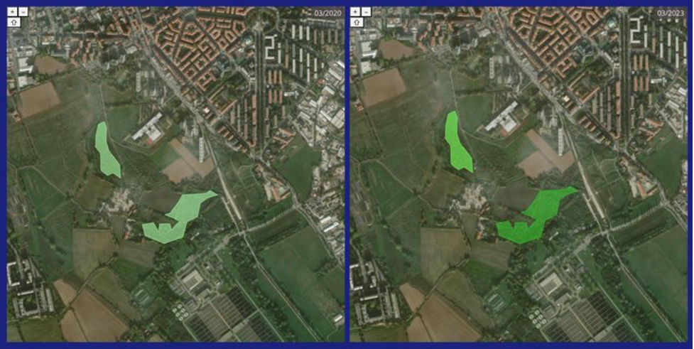
Green index calculated for an area in the South of Milan (left March 2020, right March 2023)
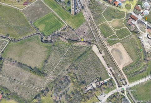
Satellite image of the analyzed area (left March 2020, right March 2023)
In conclusion, a civil servant from the Green and Environment department provided insights about how the SPOTTED outcomes can and will effectively be used to support:
- the Milano Municipality urban management and planning, for those plans, policies, and strategies related to the city’s goal of climate adaptation set for 2050 within the ‘Air and Climate Plan’ (PAC), and
- to the biannual PAC monitoring.
Zooming in PAC, SPOTTED digital services will be used to monitor the three urban indicators of green index, heat islands (UHI), and heat-wave risk. Accordingly, Milan is also foreseeing to make use of the SPOTTED platform and the related datasets as a supporting tool:
- to identify districts with higher heat risk,
- to identify census sections with greater UHI effect (within the high heat risk urban district boundaries)
- to identify potential intervention areas to be “vegetated” to meet the climate adaptation goals.
A positive reaction and big interest in SPOTTED was that, during the Q&A, many questions arise about the ‘future’ of the project and related platform, both in terms of geographical replicability and services scalability. These audience inputs are surely a litmus test of deep interest in the project objectives, as well as increasing need from public administration for data-driven services which can inform and support smart cities development.